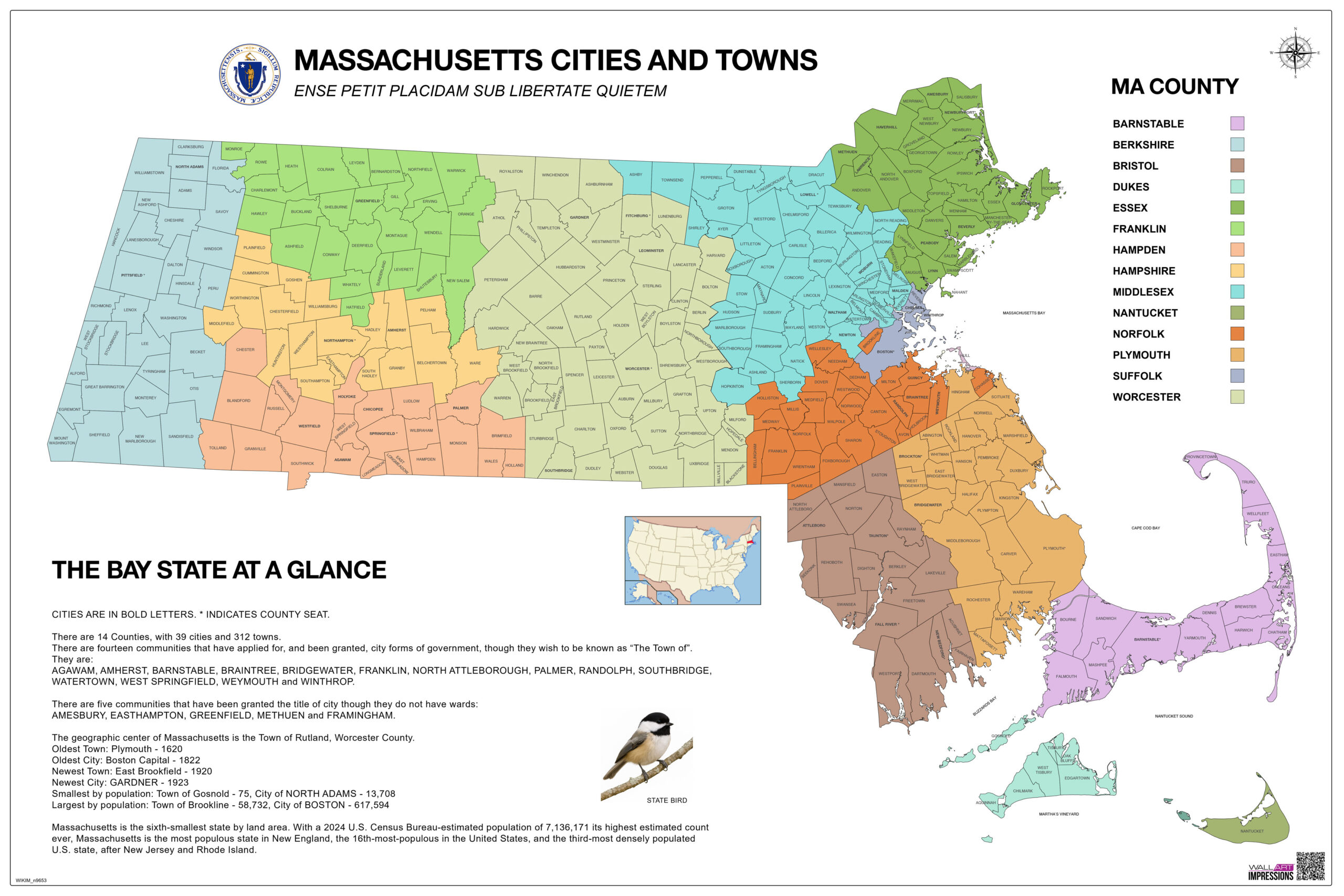
36x24in Color-Coded Poster Map of Massachusetts Cities, Towns and County Seats
Trusted by thousands of customers across Amazon, Walmart and Etsy – now available direct.
Shop Wall Art Impressions for a detailed map of Massachusetts showcasing all 14 counties and their cities and towns in vivid, easy-to-read color coding. Ideal for home, office, or classroom. Track your travels or use as an educational resource.
Map of Massachusetts Cities and Counties Features:
Complete Coverage: All 14 counties of Massachusetts clearly labeled and color-differentiated
Cities & Towns Included: Every incorporated municipality is marked for easy reference
County Seats Highlighted: Important civic centers indicated in bold for quick identification
Inset Map: Includes a mini U.S. location map to show Massachusetts’ place in the country
Includes: The Black-Capped Chickadee – State Bird of Massachusetts
How this map can enhance learning? Read our guide on the best educational uses for a Massachusetts county map

Madison Bryant –
Received the wrong item, but the replacement process was smooth and quick.
Joshua Jenkins –
VERY speedy delivery and clear design and durable lamination.
FDY –
Great map, it arrived quickly and will be perfect in my classroom!
Emily Tomas –
The quality of the print is excellent, and the details are clear. It’s perfect for my office wall and great for tracking activities and trips. Highly recommend it!
Mark –
Love this map! As a Massachusetts native, it’s so nice to have a well-designed representation of my home state.
📌 –
happy with the map
Daniel Ray –
I’ve been using it to plan and track my hiking adventures across Massachusetts. I wish it was available in a framed option, but it still looks amazing.
Linda S. –
I bought this map for my study room, and I couldn’t be happier. The quality of the paper feels premium. Arrived well-packaged and on time.
Nicole Price –
The print quality is exceptional, with clear and legible text, laminated finish adds a layer of durability