Dallas – Fort Worth Metroplex Travel Map with Cities & Roads. Includes Dallas, Fort Worth, Plano, Arlington, Irving & More [24×36]
![Dallas - Fort Worth Metroplex Travel Map with Cities & Roads. Includes Dallas, Fort Worth, Plano, Arlington, Irving & More [24x36] picture](https://wallartimpressions.com/wp-content/uploads/2025/05/68309c2aa06b3-dnf-31.jpg)
![Dallas - Fort Worth Metroplex Travel Map with Cities & Roads. Includes Dallas, Fort Worth, Plano, Arlington, Irving & More [24x36] picture](https://wallartimpressions.com/wp-content/uploads/2025/05/68309c2b1b1f7-dnf-31_variant2.jpg)
![Dallas - Fort Worth Metroplex Travel Map with Cities & Roads. Includes Dallas, Fort Worth, Plano, Arlington, Irving & More [24x36] picture](https://wallartimpressions.com/wp-content/uploads/2025/05/68309c2ad85a6-dnf-31_variant1.jpg)
| Weight | 8 oz |
|---|---|
| Dimensions | 26 × 2 × 2 in |
| Finishing Options |
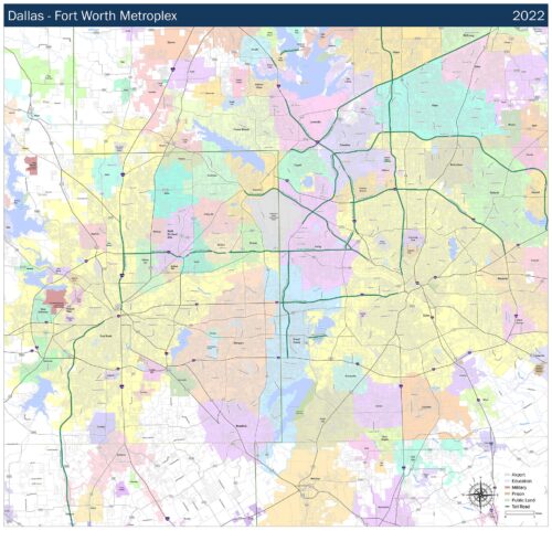
Dallas – Fort Worth Metroplex Travel Map with Cities & Roads. Includes Dallas, Fort Worth, Plano, Arlington, Irving & More [24×36]
This highly detailed 2023 Dallas-Fort Worth Metroplex Street Map is an essential wall reference for businesses, educators, and planners. Covering the entire DFW area, it includes major cities like Dallas, Fort Worth, Arlington, Plano, Irving, Garland, Denton, and more. Streets, highways, and toll roads are clearly labeled for precision and readability. Perfect for office walls, dispatch centers, or educational use, this wall map helps visualize North Texas in one comprehensive layout.
How to Choose the Right Finish for Your Map
similar maps
Reviews
There are no reviews yet.